A next-generation Marine RS index -
deep penetrating and dealing with the root of life
Remote sensing (RS) holds enormous promise for revealing the hidden dynamics of
our ecosystems—but that promise remains largely untapped. In marine
environments, for example, conventional indices rarely penetrate below the
surface to capture deeper ecological processes.
Introducing the
Marine Photosynthesis Index (MPI)
Under the EU Biodiversa+ project
Climate Invasives, WP leader Erik Prins has developed and validated a
novel RS index capable of sensing far below the water’s surface. The result is
the Marine Photosynthesis Index (MPI)—a multispectral algorithm designed
to:
- Penetrate deeply
(>12 m in Kattegat; up to ~50 m in the Red Sea), compared to 0.2–2 m for
standard vegetation indices.
- Detect prokaryotes,
the most species-rich group on Earth, and other microscopic life forms—opening
a window onto ecosystem functions rooted in microbial evolution.
- Reveal critical
ecosystem indicators, including upwelling events,
algal blooms, and oxygen-depletion risk.
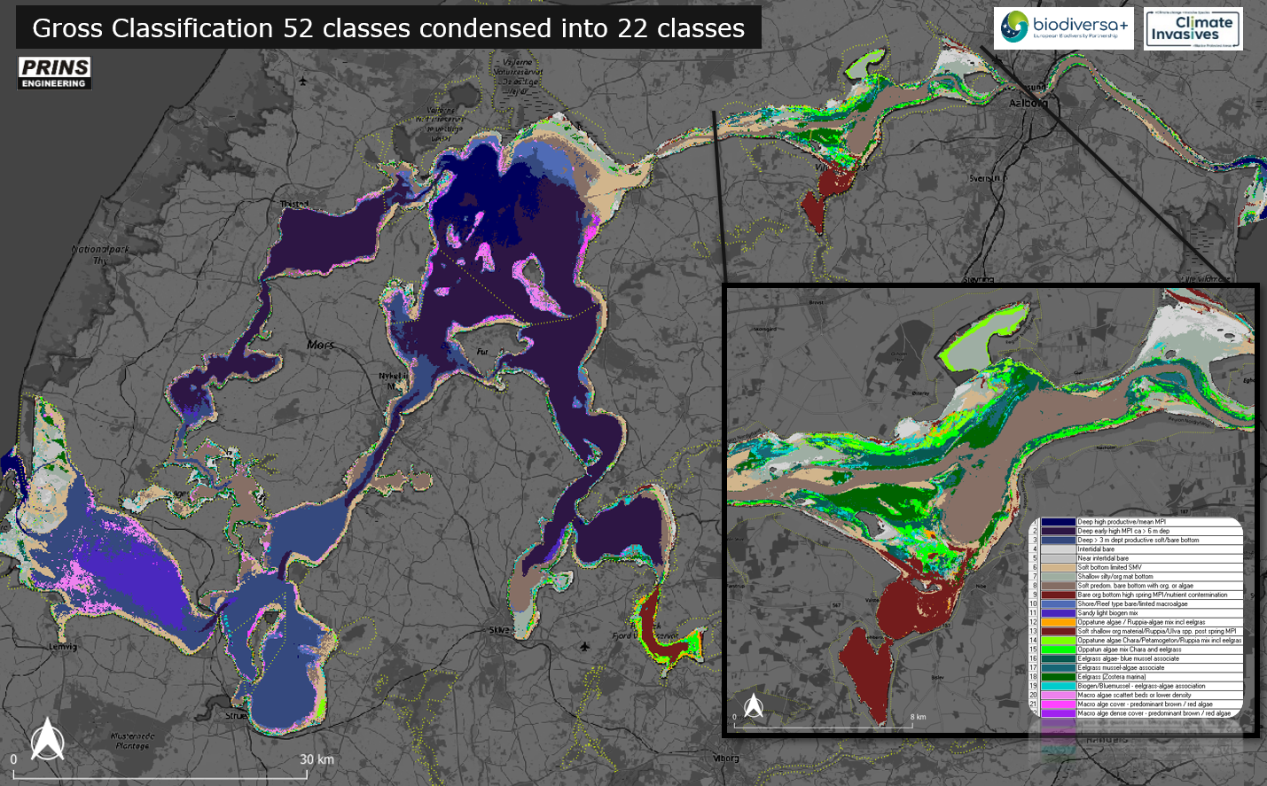
- Enable fine-scale
benthic mapping, demonstrated by a full-area, 20
m-resolution habitat map of Limfjorden.
- Support temporal
monitoring, offering early warning of toxic blooms,
nutrient surges, and emerging marine “hot spots.”
MPI debuted at ESA’s BioSpace25 Conference
(10–14 Feb 2025) and shows promise across many applications:
- Free-water mass analysis
- Benthic habitat
classification
- Tracking nutrient or
bloom pollution
-
Forecasting oxygen depletion
Key Limfjorden Findings
Multitemporal MPI show features of ecosystem
fuctionality - from what appears to be bentic vegetations association with
microorganism to bottom conditions e.g. from sand to organic bottoms with high
spring response - indicating potential for oxygen depleation.

- Eelgrass expansion
(Zostera marina) mapped with >85 % accuracy against Denmark’s NOVANA
ground surveys—an excellent result given seasonal and methodological
differences.
Download Metadata ISO 91130 / INSPIRE for
Limfjord 2023 habitat map, ask for data.
Benthic mapping
based upon MPI (2023) - unfolding the deeper waters (ca > 4 m) can be viewed below
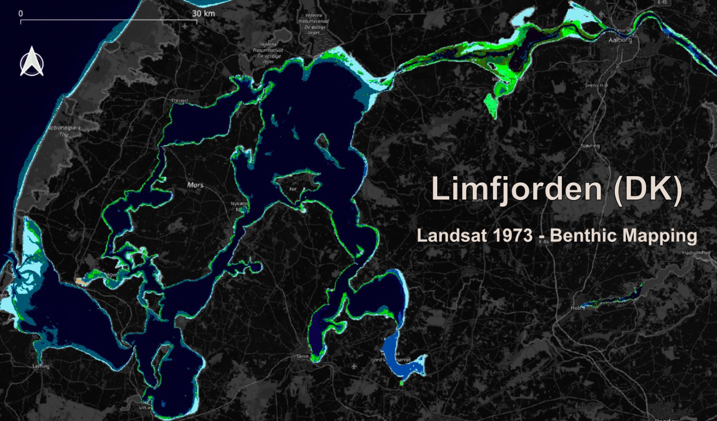
Example of benthic mapping
based upon Landsat data and AI modeling uncovers the extent of e.g.,
softbottoms and Eelgrass (green) in 1973
Penetrating the deeper waters of Limfjorden
- High mean MPI values co-occur with
productive fisheries, blue mussel beds, and both native and invasive oyster
populations.
- Cluster analysis of multi-temporal MPI
delineates distinct water masses, including zones prone to oxygen depletion.
- Exceptional sensitivity to
algae blooms makes MPI a powerful early-warning tool.

- MPI uncovers
upwelling events in Northern Kattegat, Skagerrak,
and the Red Sea.
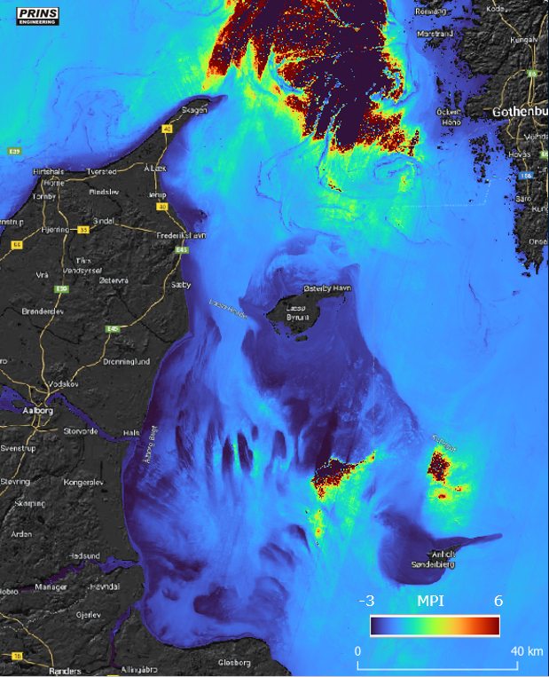
Example of upwelling event in northern Kattegat captured via MPI - the
center upwelling pulse show extreem low values surounded by extreem high MPI values by
activation of foundation species. Furthermore, the image illustrates the deep penetrating ability
e.g., sand bares or banks in darker blue.
A New Window on Evolution and
Ecology
Built on principles of microbial evolution—recognizing
prokaryotes as the planet’s foundational life forms—MPI goes beyond mapping. It
forges a direct link between evolutionary processes
and ecosystem function, offering a
revolutionary approach to understanding and managing marine biodiversity.
Explore
MPI and its applications across diverse marine environments—wherever a
deeper look beneath the waves can illuminate the health of our oceans.
The Climate Invasive project deals with the understanding
of how Climate change, ecosystem dynamics and IAS are impacting marine
protected areas. This basically require mapping of marine habitats and change.
The project furthermore analysis and models oceanographic data as well as eDNA
aiming at forecasting and spreading of alien invasive species.
The aim of EU Biodiversa+ is to develop
strong tools for next generation assessment of biodiversity across EU.


Example of benthic mapping
of Swedish core area
based upon Sentinel 2 data and AI modelling (left) and an AIS on the right.


Client: EU
Funding: InnovationFund (DK), EU and Prins (>25%)
privacy2025@prins engineering.com