DeVELOPMENT OF AGRO-ENVIRONMENTAL INDICATORS
FOR EVALUATION 0F BIODIVERSITY IN THE LATVIAN FARMLAND.
Since the
establishments of a new EU CAP in 1998 the E.C. have committed them to integrate
the environment into their agricultural policies. Presently, EU put big effort
into the establishment of agro-environmental indicators.
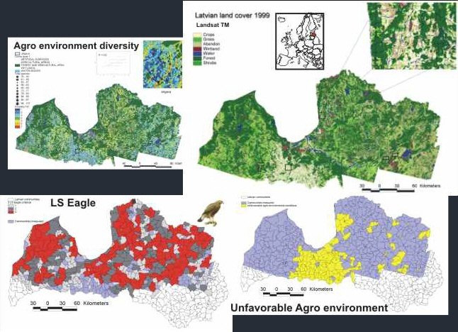
Landsat data were used as basic for modelling agro-environmental landscape quality, by the use of Fragstat measures.
The project
“Biodiversity management in the Latvian farmland - a decision support system”
(1995-2001), was already in 1994 designed for modeling biodiversity measures and
agro-environmental indicators by integrating systematic biological field
observations with satellite derived land cover data.
The study result
showed that measures suggested to be used within EU for evaluation of
biodiversity in west European agriculture did respond to species richness, but
not to red-listed species. Novel GIS methods was developed to produce predicted
species maps for birds as well as using FRAGSTAT for compiling bird species
respond to landscape architecture. The project identified Lesser Spotted eagle
as the most suited agro-environmental indicator - it has high environmental
demands and responds to large scale landscape measures. Lesser Spotted eagle is
used as agro-environmental indicator in the Latvian SAPARD program.
The project
consisted of a study part and furthermore, capacity building to the Latvian
ministry of environment and ministry of agriculture. The project results added
to development of the Latvian agricultural policy.
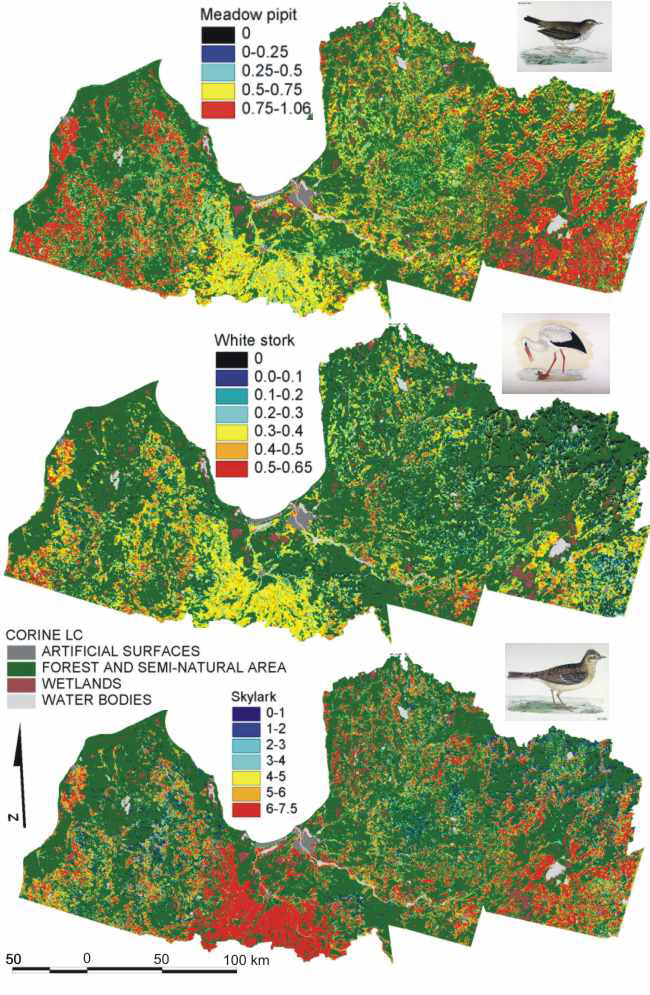
A novel method to assess species from satellite data: regression models
of bird species were implemented into the classified satellite data to produce
predicted species maps.
PRINS, E.,
PETERSEN, B., S., AUNINS A. and PRIEDNIEK, J.(2005): Using Landsat TM and field
data to produce
maps of predicted
bird densities in Latvian farmland. Int. J. of Remote Sensing, Vol 26,
No 9 p 1881 – 1891.
Aunins, a, petersen, b.s.,Priednieks, J., & Prins, e. (2001):
Bird-habitat relationships in Latvian farmland.
ACTA ORNITHOLOGICA
36:1.
Priednieks, J., A. Aunins, S. Brogger-Jensen & E.Prins (1999):
Species-habitat relationships in
Latvian farmland: studies of breeding birds in a changing agricultural
landscape. VOGELWELT, 120
Suppl.: 3-5 p 163-175.
Prins (2001)
Methods for indication of biological values and biodiversity in Latvian
farmland - Spatial analysis
of land use/cover
and landscape in relation to distribution of birds in the farmland. Technical
report: Prepared
for the project:
“management of biodiversity in the Latvian farmland – a decision support
system”by Erik Prins
Febuary 2001.
DANCEE/Ornis Consult Ltd.
Aunins A, Kalviskis K and Prins, E. (2000): Telpiskas
informacijas sistemas un attala izpete, Latvian Fund for
Nature, Riga 2000, ISBN-9984-9356-3-9. – First official
publication on RS/GIS in Latvian.
Client: DANCEE 1995-2001
privacy@prins engineering.com
About Us |
References
|
Services |
CV's |
Contacts |
Press
Copyright © PRINS, Eng. 2025