ESTABLISHMENT OF A DECISION
SUPPORT SYSTEM/ DATABASE FOR MANAGEMENT OF NATURA 2000 SITES
IN LITHUANIA
A decision support system
for management of Natura 2000 sites was established in Lithuania for ministry of
environment. A part of the project was to produce management plans for habitat
areas which should be managed locally. The system is based upon reporting from
the individual protected areas offices. The system should then collect
information on management tasks for the individual areas are carried out and as
such as a reporting system for the individual protected areas. Including
conservation status of habitats and species. The system was designed to spot
irregularities and summarize information to the annual reporting to EU.
The output result
is that management of SPAs and Special Areas of Conservation (SACs) will benefit
from the development of a coherent and well functioning database as well as
Geographical Information System (GIS) to support decision-making and
implementation of management decisions.
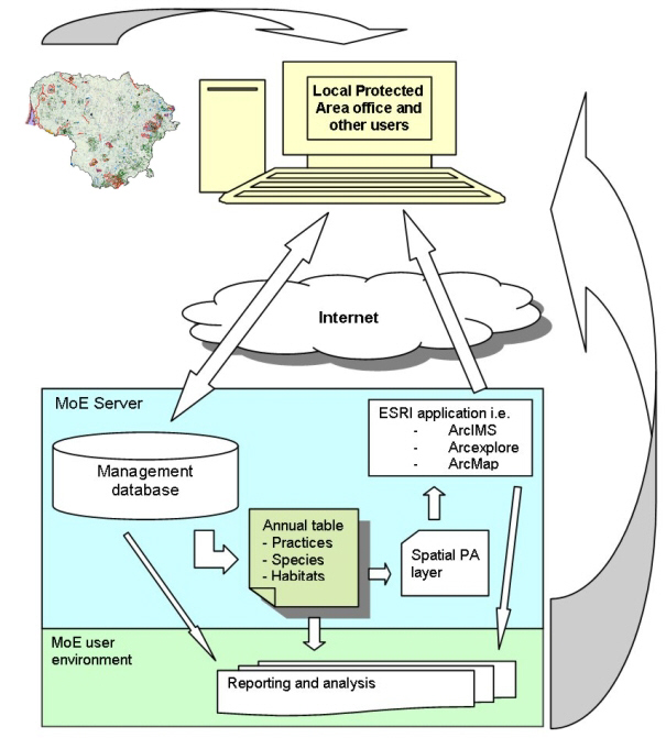
Set-up of the decision
support system for management of Natura 2000 protected area i Lithuania.
Basically the
management information system buids
upon a database which will collect information on the practices implemented to
manage the PAs. These practices will relate to different zones of the PAs and
the database will make use of the existing GIS information to produce maps of
all areas protected. Furthermore, information about species and habitats will be
entered into the database to allow monitoring. The system is designed to collect
enough information to evaluate if the management practices meet the requirements
defined for the PAs.
The previous
DANCEE projects have made inventories of
available relevant data included in existing databases in Lithuania. Besides
this information, a huge amount of data was accumulated during four field
seasons of the former DANCEE projects.
This database
also includes data from remote sensing and results of analysis such as final
boundaries and inner zones of the proposed areas.
As a central
management system, the database will 1) monitor management practices carried out
in relation to those set out by the management plans for each PA, and 2) store
information from each site on the status of key protected species/habitats. The
system will operate with database forms that can be used directly on the
Internet, optionally linked directly to a central database. The database form
contain information on:
·
Site,
·
Date of monitoring,
·
Number of species observed,
·
Reasons for deviation in monitoring guidelines/observed
species,
·
Status of management tasks,
·
Reason for changes, etc.
This information
will altogether produce a background to evaluate the status of specific sites as
well as all sites.
Client:
Ramboll/EU Phare
privacy@prins engineering.com